Alyssa Rawinski
Alyssa will graduate in May 2023 from Western Colorado University with a major in wildlife biology and conservation, a minor in chemistry, and a GIS certificate. In 2021, Alyssa completed an independent research project on burying beetles at the Rocky Mountain Biological Laboratory and this summer, she worked as a wildlife intern for the Bureau of Land Management leading a pollinator project and helping with various other management actions. This fall semester, Alyssa will be studying wildlife management in Tanzania and incorporating GIS into her projects and work abroad.
Madzie Boyles
Madzie is entering their Junior year at Colorado State University studying Ecosystem Science and Sustainability, with a focus on Geospatial Information Science and Diversity and Equity in Natural Resources. Through their academic studies they have learned basic geospatial skills in the ArcGIS suite as well as gained experience in geospatial fieldwork and methods. Madzie is excited to learn more about utilizing Python for GIS this upcoming school year.
Antonio Luna
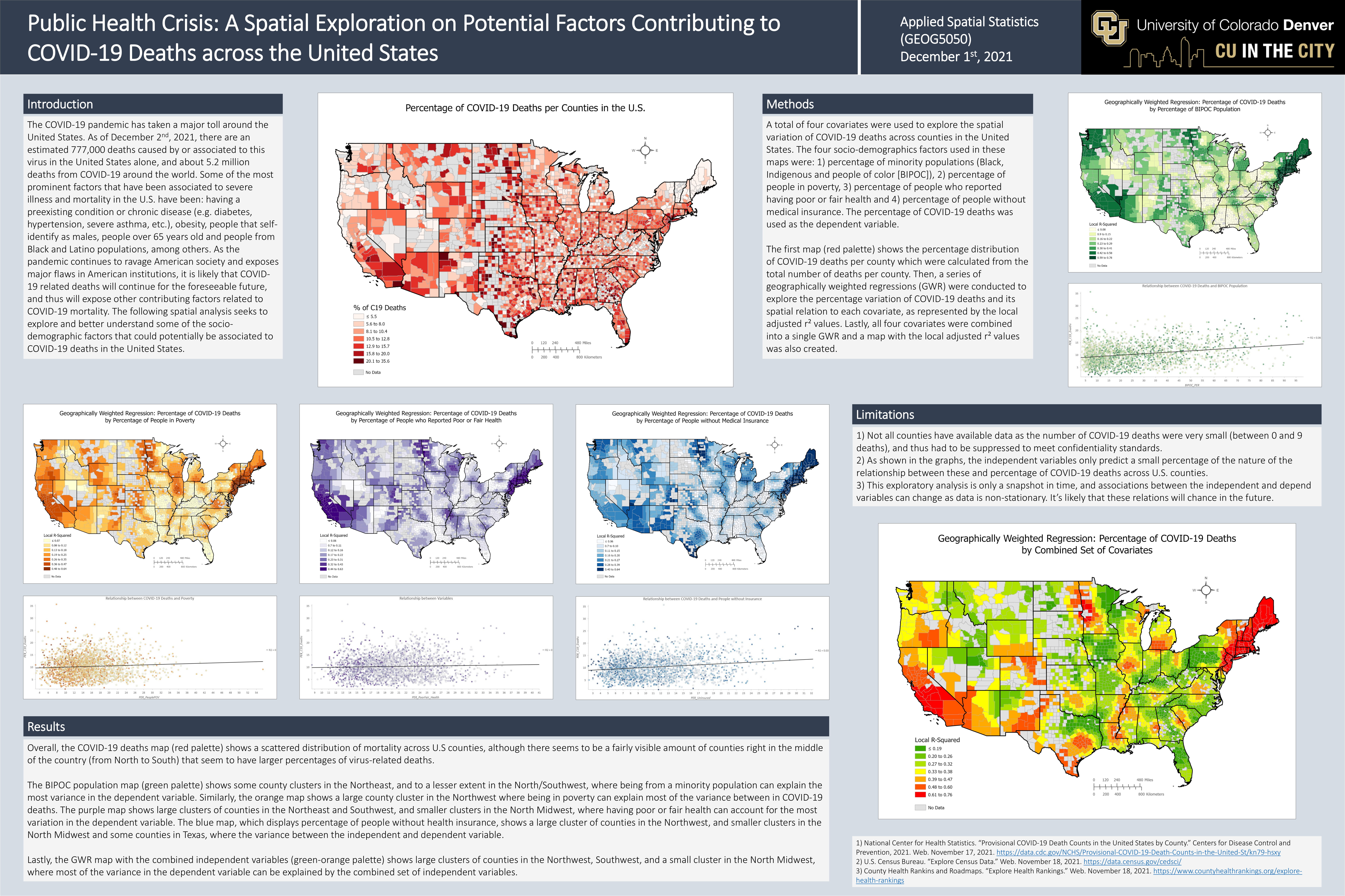
Antonio is a graduate student pursuing a MS degree in Environmental Sciences and GIS Certification at the University of Colorado Denver. His academic work revolves around research, analysis, and dissemination of socio-ecological dynamics (specifically the effects and impacts of climate change in society) and public health matters using GIS applications and technologies. Previous professional work has revolved around GIS integration and analysis of COVID-19 data projects (e.g., COVID-19 wastewater monitoring data and public-facing dashboard, analysis of COVID-19 vaccine and therapeutic distribution data in Colorado, etc.), as well as conducting statistical analysis and evaluation for CO’s MIECHV and LAUNCH programs at CDPHE. Antonio’s hope is to continue researching, analyzing, and disseminating the societal and public health impacts of a changing climate using GIS applications and technologies, and work with others to help inform and develop mitigation and adaptations strategies to address these socio-ecological issues.
Amanda Hastings
Amanda is pursuing a MS in Forest Sciences (with an emphasis in GIS) at Colorado State University and received a BS in Honors Biology from Appalachian State University. In addition to her MS research on forest recovery post-wildfire, she secured a graduate internship at the Geospatial Centroid, where she creates cartographic products for publication and works on projects rooted in spatial analysis. She also teaches “Geospatial Applications in Natural Resources” lab sections at CSU. Post-graduation, Amanda hopes to integrate GIS, cartography, data visualization, and remote sensing in her professional work.


