Tess Carson
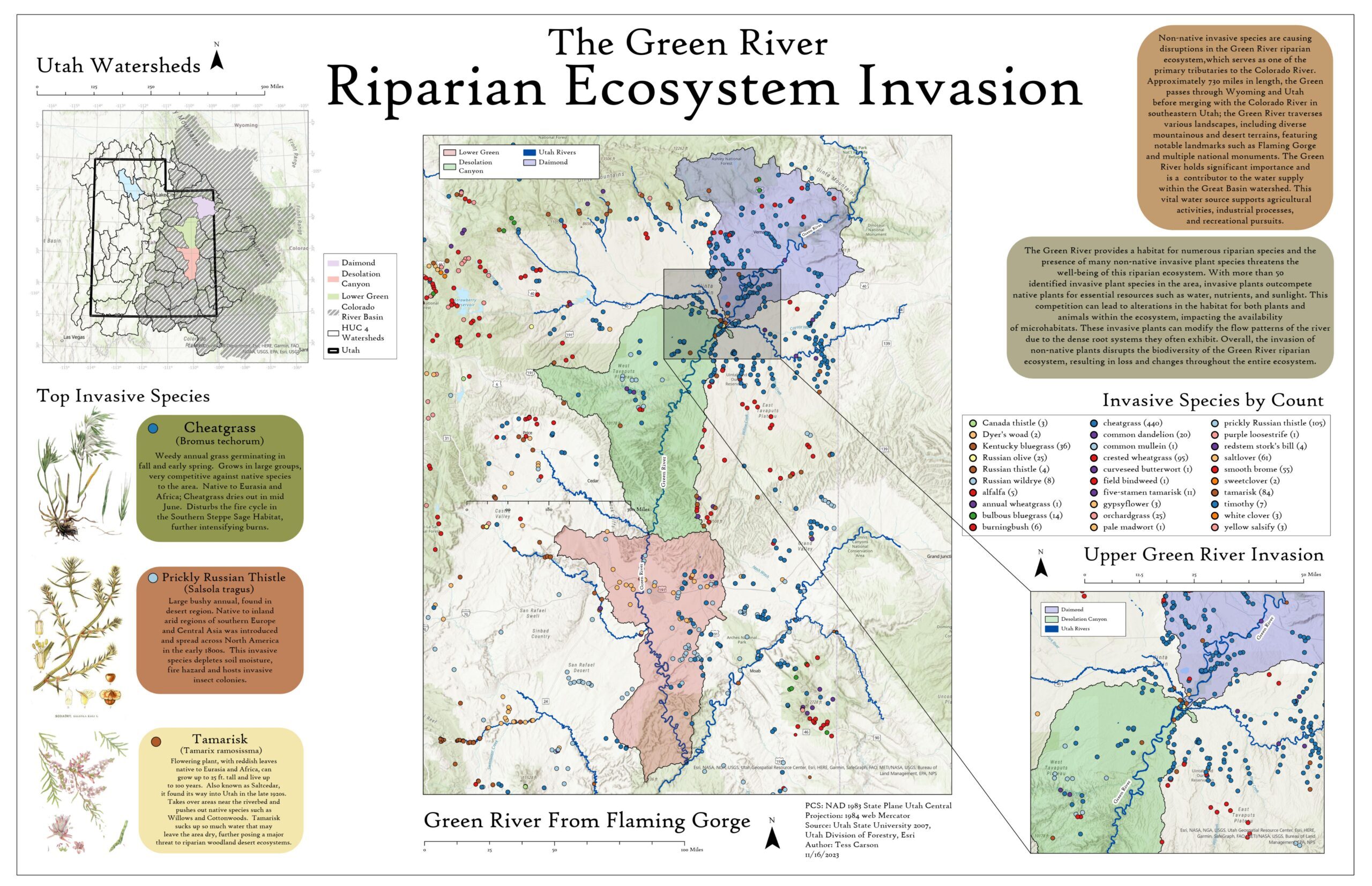
Tess is an undergraduate student seeking a B.S. in GIS with minors in Computer Science and Indigenous Studies at the University of Denver. Tess plans to continue this research create more accurate predictive Tamarix distribution models over a larger geographic scale. This map aims to catch the eye of river enthusiasts like myself and spread awareness about the large-scale invasive species invasion across the western United States. By visually representing the extent of invasive species with the use of ArcGIS and public data models from USU, Utah Forestry and Esri the graphic is intended for an audience that includes conservationists, ecologists, and the general public who have an interest in preserving riparian ecosystems.
Brett Noeske
Brett Noeske is attending Front Range Community College pursuing an associate degree in wildlife technology and a certificate in GIS. This project looks at the avian conservation issue of bird collisions and where there may be an increased risk of collisions based on certain criteria. It is intended to help spotlight areas where collisions may occur to help with mitigation efforts to reduce bird collisions.
Josh Carrell
This project aims to use spatial data on forest biotic disturbances, forest types, and climate patterns (precipitation, temperature, etc.) to investigate spatiotemporal forest recovery in the Southern Rockies ecoregion. The primary research question is: “How do spatially overlapping biotic disturbances affect subsequent forest recovery?” Josh utilized geoprocessing tools from the spatial statistics toolbox in ESRI ArcGIS Pro (e.g., Hot-spot analysis, Geographically Weighted Regression) to identify patterns and spatial relationships among co-occurring insect and disease outbreaks and environmental variables (i.e., Elevation, Aspect, Slope) across the Southern Rockies to answer this question.
Sabrina Gobran
This project aims to use remotely sensed data and active tick surveillance to explore how wildfire disturbance impacts tick populations. To explore these relationships, the differenced Normalized Burn Ratio (dNBR) and spatial distribution and abundance of tick populations were mapped for Larimer and Boulder counties. Landsat 8 OLI/TIRS sensor images obtained from Google Earth Engine were used to assess the Normalized Burn Ratio (NBR) following the Cameron Peak fire.


